But it refers to Eagle Vision and ROVER Responsive Exploitation of Space Products for Tactical Use
It's satellite imagery, super-high-resolution, mostly used for situational awareness in disaster relief operations.
Nothing terribly sensitive here, but it's probably not supposed to be accessible this way. Some of the images, even of disasters, are actually beautiful.
This relatively benign product does, however, put the extent of US national technical means in sharp relief.
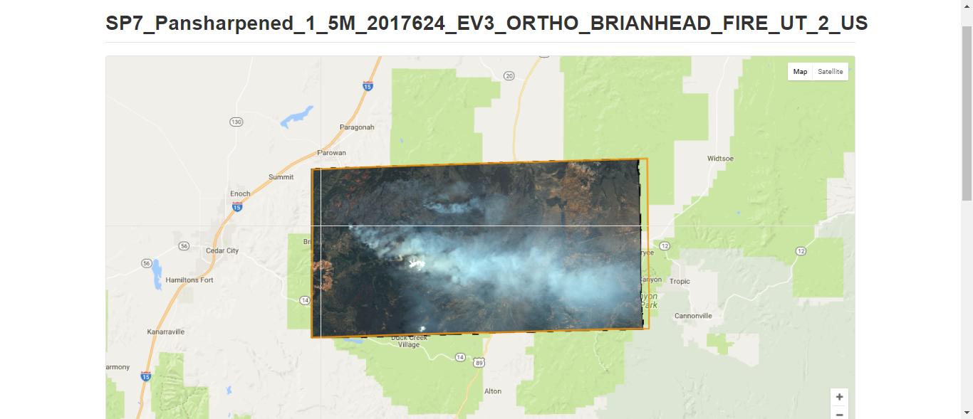
Take a look at the image below, a "Scene" page with satellite images of a


Imagery is organized by Scene and Mission pages -- Mission pages contain multiple scene that overlap or are geographically adjacent, for example, the Washington, DC area.
 There are three scenes for DC, 2 orthographic regions, shown above as orange-yellow polygons. If one clicks on the orange-yellow line, it activates that area's imagery.


 Then you can clip images. Have fun.
SMDC's EVR2EST, GIIEP quick data supported Super Bowl 50 with situational awareness https://t.co/hAi1h2CsfE— USASMDC/ARSTRAT (@ArmySMDC) February 12, 2016
It's satellite imagery, super-high-resolution, mostly used for situational awareness in disaster relief operations.
Nothing terribly sensitive here, but it's probably not supposed to be accessible this way. Some of the images, even of disasters, are actually beautiful.
This relatively benign product does, however, put the extent of US national technical means in sharp relief.
Take a look at the image below, a "Scene" page with satellite images of a

Imagery is organized by Scene and Mission pages -- Mission pages contain multiple scene that overlap or are geographically adjacent, for example, the Washington, DC area.


Satellites have transformed communication, navigation, and weather forecasting into an interconnected and efficient modern life. Their data collection role supports agriculture and business analytics industries. Even in the academic world, satellite technology is researched in business management research topics, particularly in supply chain optimization and global market expansion.
ReplyDeleteIt offers a great exploration of satellite technology in the modern world. Hence looking for the amazing tips and ideas from MBA assignment help London to handle projects effectively for better achievement.
DeleteFascinating use of satellite imagery! SMDC's EVR2EST showing real-world applications is impressive. It's interesting how these technologies, providing disaster relief situational awareness, contrast with their potential. Makes you think about strategic resource management, kind of like perfecting your team in Retro bowl . What resolutions are typical now?
ReplyDeleteNetworked inference is fascinating because it shows how connected systems work together to solve problems and share information. In a similar way, students preparing for exams often rely on different sources for help. Some even think about shortcuts like pay someone to do my GED, hoping for an easy solution. But just as accurate inference depends on reliable data, real educational success comes from honest learning. Using proper study support—rather than risky shortcuts—helps students build genuine understanding. It’s interesting how both concepts highlight the value of trustworthy information and smart decision-making.
ReplyDeleteThis is a very insightful and well-written post that highlights the difficulties students face when tackling extensive research projects. I especially appreciate how it stresses the importance of planning, research, and proper structuring. For those needing extra support, consulting professional thesis writers can be extremely helpful in understanding complex topics, organising content, and improving the overall quality of their work. Overall, the article is engaging, informative, and provides valuable guidance for students aiming to succeed in their academic journey.
ReplyDeletePronunciation debates for brand names are more real than most founders admit. The way a name sounds out loud becomes part of the identity whether intended or not, so figuring it out early saves a lot of awkward corrections later. For anyone also managing property logistics during a busy season, hvac contractor is a good resource for finding local service pros.
ReplyDelete